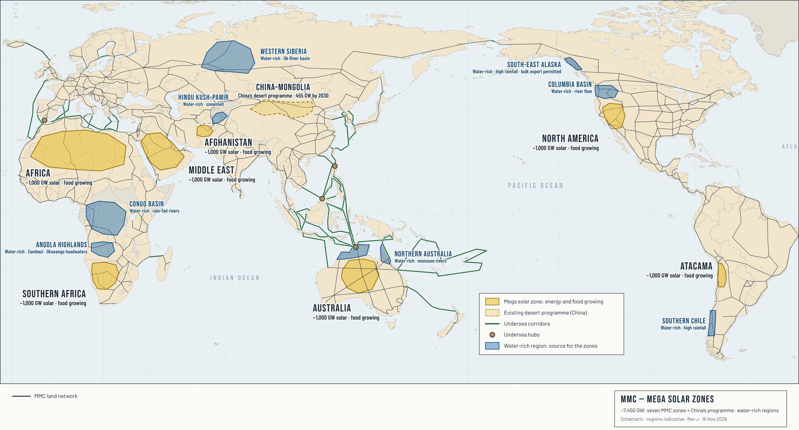
The blue regions on the map have more water than they use. Each one is paired with a solar zone. The surplus is captured, pumped on the MMC aqueduct to pumped hydro dams on the network, and used to grow food, cool the AI centres and supply the new cities.
Past transfer schemes needed their own canals. On the MMC, the water travels in the MMC-VA aqueduct, built as part of the corridor: roofed and pumped as a pipe where the route climbs, and an open channel where it falls by gravity. One MMC-VA line carries about 10,000 GL a year (Aqueduct), so any nation on the network can move water.
Northern Australia → Australia
Monsoon flows
Wet-season flows from the north, carried south by the MMC-VA aqueduct to the Alice Hub water battery in the MacDonnell Ranges.4,5
Congo Basin → Sahara
River offtake
Water from the Ubangi–Congo tributaries, carried north. Transaqua proposed a 2,400 km canal carrying 100 billion m³ a year from the Congo to Lake Chad; the DRC opposed it in 2018.21,22
Angola Highlands → Southern Africa
River offtake
The Cunene already supplies northern Namibia: water is pumped at Calueque Dam in Angola, an agreed 6 m³/s, and carried about 150 km by canal.23
Columbia Basin → Nevada
River offtake
At Grand Coulee, 12 pumps lift Columbia water to Banks Lake to irrigate about 670,000 acres; six of the twelve can reverse and generate, a working water battery.24
South-East Alaska → Nevada
Lake outflow
Sitka holds a state permit to export about 9.5 billion gallons a year from Blue Lake. No large bulk export has yet been made.25
Southern Chile → Atacama
River offtake
Chile’s “water highway” proposals carry surplus water from the Biobío region north to Atacama by canal and aqueduct; a subsea pipeline version has also been put forward.26
Hindu Kush–Pamir → Afghanistan
Snowmelt rivers
Afghanistan is building the 285 km Qosh Tepa canal from the Amu Darya to turn 550,000 hectares of desert into farmland.27
Western Siberia → Afghanistan and China–Mongolia
River offtake
The Ob basin. Siberian rivers discharge about 3,000 km³ a year into the Arctic; the Russian Academy of Sciences is assessing sending 1–2% of the Ob’s flow south to Central Asia.29,30
Red Sea and Gulf → Middle East
Desalination
No water-rich region is close. Sea water is desalinated on the zone’s own solar and piped in.
Shared rivers. Several of these rivers cross borders. The DRC has opposed taking Ubangi water north
22; the Qosh Tepa canal could take an estimated 25–30% of the Amu Darya’s flow, and downstream Central Asian countries have raised concerns
28; the Cunene supply runs under an Angola–Namibia agreement
23; the Soviet plan to divert Siberian rivers south was abandoned in 1986 over environmental risk, and the revived Ob study needs a long-term Russia–Central Asia partnership
29,31. Each transfer needs agreement between the nations on the river.